This is an interactive map! Use controls to pan and zoom this map.
Access
|
English (Translate this text in English): The dive site is in Halifax County, through the community of Hubbards, and on to Route 329 on the coastal road on the west side of St. Margaret's Bay. The spot is just past Mill Cove, once you enter the strip community of Birchy Head. It is marked by an old, broken down, and partially burnt FISH SHACK on the left side of the road going out...One has to turn around and park on the shoulder of the road facing back along by the shack. There is tight parking for 5 vehicles.
English (Translate this text in English): The dive site is in Halifax County, through the community of Hubbards, and on to Route 329 on the coastal road on the west side of St. Margaret's Bay. The spot is just past Mill Cove, once you enter the strip community of Birchy Head. It is marked by an old, broken down, and partially burnt FISH SHACK on the left side of the road going out...One has to turn around and park on the shoulder of the road facing back along by the shack. There is tight parking for 5 vehicles.
The dive site is in Halifax County, through the community of Hubbards, and on to Route 329 on the coastal road on the west side of St. Margaret's Bay. The spot is just past Mill Cove, once you enter the strip community of Birchy Head. It is marked by an old, broken down, and partially burnt FISH SHACK on the left side of the road going out...One has to turn around and park on the shoulder of the road facing back along by the shack. There is tight parking for 5 vehicles.
English (Translate this text in English): The dive site is in Halifax County, through the community of Hubbards, and on to Route 329 on the coastal road on the west side of St. Margaret's Bay. The spot is just past Mill Cove, once you enter the strip community of Birchy Head. It is marked by an old, broken down, and partially burnt FISH SHACK on the left side of the road going out...One has to turn around and park on the shoulder of the road facing back along by the shack. There is tight parking for 5 vehicles.
English (Translate this text in English): The dive site is in Halifax County, through the community of Hubbards, and on to Route 329 on the coastal road on the west side of St. Margaret's Bay. The spot is just past Mill Cove, once you enter the strip community of Birchy Head. It is marked by an old, broken down, and partially burnt FISH SHACK on the left side of the road going out...One has to turn around and park on the shoulder of the road facing back along by the shack. There is tight parking for 5 vehicles.
English (Translate this text in English): The dive site is in Halifax County, through the community of Hubbards, and on to Route 329 on the coastal road on the west side of St. Margaret's Bay. The spot is just past Mill Cove, once you enter the strip community of Birchy Head. It is marked by an old, broken down, and partially burnt FISH SHACK on the left side of the road going out...One has to turn around and park on the shoulder of the road facing back along by the shack. There is tight parking for 5 vehicles.
English (Translate this text in English): The dive site is in Halifax County, through the community of Hubbards, and on to Route 329 on the coastal road on the west side of St. Margaret's Bay. The spot is just past Mill Cove, once you enter the strip community of Birchy Head. It is marked by an old, broken down, and partially burnt FISH SHACK on the left side of the road going out...One has to turn around and park on the shoulder of the road facing back along by the shack. There is tight parking for 5 vehicles.
English (Translate this text in English): The dive site is in Halifax County, through the community of Hubbards, and on to Route 329 on the coastal road on the west side of St. Margaret's Bay. The spot is just past Mill Cove, once you enter the strip community of Birchy Head. It is marked by an old, broken down, and partially burnt FISH SHACK on the left side of the road going out...One has to turn around and park on the shoulder of the road facing back along by the shack. There is tight parking for 5 vehicles.
English (Translate this text in English): The dive site is in Halifax County, through the community of Hubbards, and on to Route 329 on the coastal road on the west side of St. Margaret's Bay. The spot is just past Mill Cove, once you enter the strip community of Birchy Head. It is marked by an old, broken down, and partially burnt FISH SHACK on the left side of the road going out...One has to turn around and park on the shoulder of the road facing back along by the shack. There is tight parking for 5 vehicles.
How? From shore
Distance Short walk from shore (< 5min)
Easy to find? Easy to find
|
|
Dive site Characteristics
Average depth 10 m / 32.8 ft
Max depth 33 m / 108.3 ft
Current None
Visibility Good ( 10 - 30 m)
Quality
Dive site quality Good
Experience CMAS * / OW
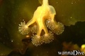
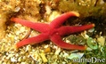
Bio interest Interesting
More details
Week crowd
Week-end crowd
Dive type
- Deep
- Ambiance
Dive site activities
- Marine biology
- Night dive
- Dive training
- Orientation
- Photography
- Handi-diving
Dangers
Additional Information
English (Translate this text in English): The path down to the shoreline is around the right side of the FISH SHACK, and is a short scramble down small boulders to and easy walk to a small granite point jutting out into the water. This point offers easy water access and is 3-9' deep, depending on tide.
The diving is on a nice boulder slope running down to 40-50' to a gravel slope that gradually drops to ~100' deep. The rich seaweeds and marine life are in the top 40' of water.
It is calm in westerly winds, as it faces due east and is good for all level of divers in light northwest to southwest winds.
The path down to the shoreline is around the right side of the FISH SHACK, and is a short scramble down small boulders to and easy walk to a small granite point jutting out into the water. This point offers easy water access and is 3-9' deep, depending on tide.
The diving is on a nice boulder slope running down to 40-50' to a gravel slope that gradually drops to ~100' deep. The rich seaweeds and marine life are in the top 40' of water.
It is calm in westerly winds, as it faces due east and is good for all level of divers in light northwest to southwest winds.
English (Translate this text in English): The path down to the shoreline is around the right side of the FISH SHACK, and is a short scramble down small boulders to and easy walk to a small granite point jutting out into the water. This point offers easy water access and is 3-9' deep, depending on tide.
The diving is on a nice boulder slope running down to 40-50' to a gravel slope that gradually drops to ~100' deep. The rich seaweeds and marine life are in the top 40' of water.
It is calm in westerly winds, as it faces due east and is good for all level of divers in light northwest to southwest winds.
 Comments
Please login to use this tool.
No account yet? Register first; it's free!
Show all (0)...
Be the first to comment this country
Errors, Feedback
You can edit this page to correct errors or add new information. If you have any problems regarding this page, Send us feedback.
Wannadive.net 24/24
Wannadive.net on your mobile

Newsletter All news by email
 The fish shack