Lost password? New user? Register
Clownfish, Philippines. Photo by Stephane Rochon.
Enjoy and contribute!
| Find the best dive sites |
|
|
 Malawi
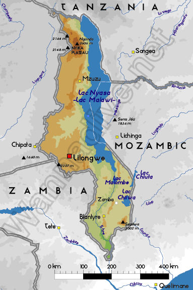
Africa
Dive Nkhata Bay !
Location: Southern Africa, east of Zambia
Geographic coordinates: 13° 18' S, 34° 0' E
Coastline km: 0 km (landlocked) km
Climate: sub-tropical; rainy season (November to May); dry season (May to November)
Terrain: narrow elongated plateau with rolling plains, rounded hills, some mountains
Elevation: lowest point: junction of the Shire River and international boundary with Mozambique 37 m
highest point: Sapitwa (Mount Mlanje) 3,002 m
Natural hazards: NA
Currency: Malawian kwacha (MWK)
Population: 12,158,924 (July 2005 est.)
Languages: Chichewa 57.2% (official), Chinyanja 12.8%, Chiyao 10.1%, Chitumbuka 9.5%, Chisena 2.7%, Chilomwe 2.4%, Chitonga 1.7%, other 3.6% (1998 census)
Capital: Lilongwe
Divisions: 27 districts; Balaka, Blantyre, Chikwawa, Chiradzulu, Chitipa, Dedza, Dowa, Karonga, Kasungu, Likoma, Lilongwe, Machinga (Kasupe), Mangochi, Mchinji, Mulanje, Mwanza, Mzimba, Ntcheu, Nkhata Bay, Nkhotakota, Nsanje, Ntchisi, Phalombe, Rumphi, Salima, Thyolo, Zomba
More details
| Jan | Feb | Mar | Apr | May | Jun | Jul | Aug | Sep | Oct | Nov | Dec | |
|---|---|---|---|---|---|---|---|---|---|---|---|---|
| Climate | ||||||||||||
| Air temp. | ||||||||||||
| Water temp. | ||||||||||||
| Equipment | ||||||||||||
| Best season | ||||||||||||
Additional map
Wanna add some info about Malawi? Let us know...
This is an interactive map! Use controls to pan and zoom this map.

- Favourite
-
Your favourites and future dive site lists
Your favorite zone isn't listed ? Add a zone
Zones
| Zones (1) | Dive sites | Sub zones |
|---|---|---|
| Lake Malawi | 13 | 0 |
 Comments
Be the first to comment this country
Errors, Feedback
If you want to add new information or you have found errors on this country, Send us feedback.
Advertise
Wannadive.net 24/24
Wannadive.net on your mobile
![]()
RSS All the RSS feeds of Wannadive.net
Newsletter All news by email