Lost password? New user? Register
Whale Shark, Philippines. Photo by Stephane Rochon.
Enjoy and contribute!
| Find the best dive sites |
|
|
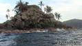
 Colombia
South America
Location: Northern South America, bordering the Caribbean Sea, between Panama and Venezuela, and bordering the North Pacific Ocean, between Ecuador and Panama
Geographic coordinates: 4° 0' N, 72° 0' W
Coastline km: 3,208 km (Caribbean Sea 1,760 km, North Pacific Ocean 1,448 km) km
Climate: tropical along coast and eastern plains; cooler in highlands
Terrain: flat coastal lowlands, central highlands, high Andes Mountains, eastern lowland plains
Elevation: lowest point: Pacific Ocean 0 m
highest point: Pico Cristobal Colon 5,775 m
note: nearby Pico Simon Bolivar also has the same elevation
Natural hazards: highlands subject to volcanic eruptions; occasional earthquakes; periodic droughts
Currency: Colombian peso (COP)
Population: 43,593,035 (July 2006 est.)
Languages: Spanish
Capital: Bogota
Divisions: 32 departments (departamentos, singular - departamento) and 1 capital district* (distrito capital); Amazonas, Antioquia, Arauca, Atlantico, Bogota*, Bolivar, Boyaca, Caldas, Caqueta, Casanare, Cauca, Cesar, Choco, Cordoba, Cundinamarca, Guainia, Guaviare, Huila, La Guajira, Magdalena, Meta, Narino, Norte de Santander, Putumayo, Quindio, Risaralda, San Andres y Providencia, Santander, Sucre, Tolima, Valle del Cauca, Vaupes, Vichada
More details
| Jan | Feb | Mar | Apr | May | Jun | Jul | Aug | Sep | Oct | Nov | Dec | |
|---|---|---|---|---|---|---|---|---|---|---|---|---|
| Climate | ||||||||||||
| Air temp. | ||||||||||||
| Water temp. | ||||||||||||
| Equipment | ||||||||||||
| Best season | ||||||||||||
Wanna add some info about Colombia? Let us know...
This is an interactive map! Use controls to pan and zoom this map.

- Favourite
-
Your favourites and future dive site lists
Your favorite zone isn't listed ? Add a zone
Zones
| Zones (2) | Dive sites | Sub zones |
|---|---|---|
| Caribbean | 35 | 7 |
| Pacific | 4 | 2 |


 Dive logs
|
Comments
Be the first to comment this country
Errors, Feedback
If you want to add new information or you have found errors on this country, Send us feedback.
Advertise
Wannadive.net 24/24
Wannadive.net on your mobile
![]()
RSS All the RSS feeds of Wannadive.net
Newsletter All news by email