Lost password? New user? Register
Whale Shark, Philippines. Photo by Stephane Rochon.
Enjoy and contribute!
| Find the best dive sites |
|
|
 Puerto Rico
Central America
Location: Caribbean, island between the Caribbean Sea and the North Atlantic Ocean, east of the Dominican Republic
Geographic coordinates: 18° 15' N, 66° 30' W
Coastline km: 501 km km
Climate: tropical marine, mild; little seasonal temperature variation
Terrain: mostly mountains with coastal plain belt in north; mountains precipitous to sea on west coast; sandy beaches along most coastal areas
Elevation: lowest point: Caribbean Sea 0 m
highest point: Cerro de Punta 1,339 m
Natural hazards: periodic droughts; hurricanes
Currency: US dollar (USD)
Population: 3,927,188 (July 2006 est.)
Languages: Spanish, English
Capital: San Juan
Divisions: none (territory of the US with commonwealth status); there are no first-order administrative divisions, but there are 78 municipalities (municipios, singular - municipio) at the second order; Adjuntas, Aguada, Aguadilla, Aguas Buenas, Aibonito, Anasco, Arecibo, Arroyo, Barceloneta, Barranquitas, Bayamon, Cabo Rojo, Caguas, Camuy, Canovanas, Carolina, Catano, Cayey, Ceiba, Ciales, Cidra, Coamo, Comerio, Corozal, Culebra, Dorado, Fajardo, Florida, Guanica, Guayama, Guayanilla, Guaynabo, Gurabo, Hatillo, Hormigueros, Humacao, Isabela, Jayuya, Juana Diaz, Juncos, Lajas, Lares, Las Marias, Las Piedras, Loiza, Luquillo, Manati, Maricao, Maunabo, Mayaguez, Moca, Morovis, Naguabo, Naranjito, Orocovis, Patillas, Penuelas, Ponce, Quebradillas, Rincon, Rio Grande, Sabana Grande, Salinas, San German, San Juan, San Lorenzo, San Sebastian, Santa Isabel, Toa Alta, Toa Baja, Trujillo Alto, Utuado, Vega Alta, Vega Baja, Vieques, Villalba, Yabucoa, Yauco
More details
| Jan | Feb | Mar | Apr | May | Jun | Jul | Aug | Sep | Oct | Nov | Dec | |
|---|---|---|---|---|---|---|---|---|---|---|---|---|
| Climate | ||||||||||||
| Air temp. | ||||||||||||
| Water temp. | ||||||||||||
| Equipment | No sé | No sé | No sé | No sé | No sé | No sé | No sé | No sé | No sé | No sé | No sé | No sé |
| Best season | ||||||||||||
Additional map
Wanna add some info about Puerto Rico? Let us know...
This is an interactive map! Use controls to pan and zoom this map.
- Favourite
-
Your favourites and future dive site lists
Your favorite zone isn't listed ? Add a zone
Zones
| Zones (5) | Dive sites | Sub zones |
|---|---|---|
| Culebra island | 6 | 0 |
| North and East | 14 | 0 |
| South East | 2 | 0 |
| Vieques island | 2 | 0 |
| West Coast and Mona Island | 6 | 0 |
Dive sites
| Dive sites (1) | Quality | Avg depth | Max depth | Experience | Dive type | ||
|---|---|---|---|---|---|---|---|
| Peñon de mera | 9 / - | 6.1 m | 12.2 m | All divers | 

|
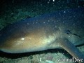
 Photos
Punta Tamarindo Grande |
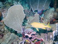
Punta Tamarindo Grande |

Punta Tamarindo Grande |

Cayo Icacos |
Dive logs
|
Comments
Errors, Feedback
If you want to add new information or you have found errors on this country, Send us feedback.
Advertise
Wannadive.net 24/24
Wannadive.net on your mobile
![]()
RSS All the RSS feeds of Wannadive.net
Newsletter All news by email