This is an interactive map! Use controls to pan and zoom this map.
Access
|
English (Translate this text in English): SW of Grand Bahama island: just W of Silver Point and E of Xanadu Beach, about 1.5 miles off the coast. Two permanent buoys mark the ship’s position (one at the bow and one at the stern).
English (Translate this text in English): SW of Grand Bahama island: just W of Silver Point and E of Xanadu Beach, about 1.5 miles off the coast. Two permanent buoys mark the ship’s position (one at the bow and one at the stern).
SW of Grand Bahama island: just W of Silver Point and E of Xanadu Beach, about 1.5 miles off the coast. Two permanent buoys mark the ship’s position (one at the bow and one at the stern).
English (Translate this text in English): SW of Grand Bahama island: just W of Silver Point and E of Xanadu Beach, about 1.5 miles off the coast. Two permanent buoys mark the ship’s position (one at the bow and one at the stern).
English (Translate this text in English): SW of Grand Bahama island: just W of Silver Point and E of Xanadu Beach, about 1.5 miles off the coast. Two permanent buoys mark the ship’s position (one at the bow and one at the stern).
English (Translate this text in English): SW of Grand Bahama island: just W of Silver Point and E of Xanadu Beach, about 1.5 miles off the coast. Two permanent buoys mark the ship’s position (one at the bow and one at the stern).
English (Translate this text in English): SW of Grand Bahama island: just W of Silver Point and E of Xanadu Beach, about 1.5 miles off the coast. Two permanent buoys mark the ship’s position (one at the bow and one at the stern).
English (Translate this text in English): SW of Grand Bahama island: just W of Silver Point and E of Xanadu Beach, about 1.5 miles off the coast. Two permanent buoys mark the ship’s position (one at the bow and one at the stern).
English (Translate this text in English): SW of Grand Bahama island: just W of Silver Point and E of Xanadu Beach, about 1.5 miles off the coast. Two permanent buoys mark the ship’s position (one at the bow and one at the stern).
How? By boat
Distance Good boat time (< 30min)
Easy to find? Hard to find
|
|
Dive site Characteristics
Alternative name M/S Logna
Average depth 25 m / 82 ft
Max depth 31 m / 101.7 ft
Current Low ( < 1 knot)
Visibility Good ( 10 - 30 m)
Quality
Dive site quality Good
Experience CMAS ** / AOW
Bio interest Outstanding
More details
Week crowd
Week-end crowd
Dive type
- Wreck
Dive site activities
- Photography
Dangers
Additional Information
English (Translate this text in English): This 230 feet long vessel was built in Norway in 1954. It was intentionally sunk october 16, 1982. She now lays on her port side on a flat sandy floor, not far from few isolated coral banks.
English (Translate this text in English): This 230 feet long vessel was built in Norway in 1954. It was intentionally sunk october 16, 1982. She now lays on her port side on a flat sandy floor, not far from few isolated coral banks.
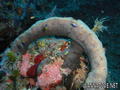
This 230 feet long vessel was built in Norway in 1954. It was intentionally sunk october 16, 1982. She now lays on her port side on a flat sandy floor, not far from few isolated coral banks.
English (Translate this text in English): This 230 feet long vessel was built in Norway in 1954. It was intentionally sunk october 16, 1982. She now lays on her port side on a flat sandy floor, not far from few isolated coral banks.
English (Translate this text in English): This 230 feet long vessel was built in Norway in 1954. It was intentionally sunk october 16, 1982. She now lays on her port side on a flat sandy floor, not far from few isolated coral banks.
English (Translate this text in English): This 230 feet long vessel was built in Norway in 1954. It was intentionally sunk october 16, 1982. She now lays on her port side on a flat sandy floor, not far from few isolated coral banks.
English (Translate this text in English): This 230 feet long vessel was built in Norway in 1954. It was intentionally sunk october 16, 1982. She now lays on her port side on a flat sandy floor, not far from few isolated coral banks.
English (Translate this text in English): This 230 feet long vessel was built in Norway in 1954. It was intentionally sunk october 16, 1982. She now lays on her port side on a flat sandy floor, not far from few isolated coral banks.
English (Translate this text in English): This 230 feet long vessel was built in Norway in 1954. It was intentionally sunk october 16, 1982. She now lays on her port side on a flat sandy floor, not far from few isolated coral banks.
 Comments
Please login to use this tool.
No account yet? Register first; it's free!
Show all (2)...
Errors, Feedback
You can edit this page to correct errors or add new information. If you have any problems regarding this page, Send us feedback.
Wannadive.net 24/24
Wannadive.net on your mobile

Newsletter All news by email
 Theo's Wreck

By Theo Galanopoulos , 14-05-2010
Theo (From Theo's Wreck) - I Like the plaque... Thanks