Lost password? New user? Register
Clownfish, Philippines. Photo by Stephane Rochon.
Enjoy and contribute!
| Find the best dive sites |
|
|
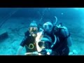
 Josie J. Wreck
Honduras, Bay Islands, Roatan Island
This is an interactive map! Use controls to pan and zoom this map.
|
Datum: WGS84 [ Help ] |
Latitude: 16° 16.166' N |
User rating (0)
- Add dive log
- Add to my dive sites
- Comments (0)
- dive logs (0)
- trips (0)
- Photos (2)
- Videos (1)
- Share
- Favourite
-
Your favourites and future dive site lists
Access
|
How? By boat & from shore Distance Short boat time (< 10min) Easy to find? Easy to find |
Dive site Characteristics
Alternative name Josie Jame Wreck
Average depth 60 m / 196.9 ft
Max depth 70 m / 229.7 ft
Current None
Visibility Good ( 10 - 30 m)
Quality
Dive site quality Great
Experience Kamikazes/Trimix
Bio interest Interesting
More details
Week crowd
Week-end crowd
Dive type
- Wreck
Dive site activities
- Dive training
- Photography
Dangers
- Depth
Additional Information
Author: Hernan Contributors (1) They dived this site ! (1)


 Comments
Be the first to comment this country
Errors, Feedback
You can edit this page to correct errors or add new information. If you have any problems regarding this page, Send us feedback.
Advertise
Wannadive.net 24/24
Wannadive.net on your mobile
![]()
RSS All the RSS feeds of Wannadive.net
Newsletter All news by email