English (Translate this text in English): Útila (Isla de Útila) is the third largest of Honduras' Bay Islands, after Roatán and Guanaja, in a region that marks the south end of the Mesoamerican Barrier Reef System, the second-largest in the world. The eastern end of the island is capped by a thin veneer of basaltic volcanic rocks, erupted from several pyroclastic cones including 74 m (243 ft) Pumpkin Hill which forms the highest point on the island. It has been documented in history since Columbus' fourth voyage, and currently enjoys growing tourism with emphasis on recreational diving.
English (Translate this text in English): Útila (Isla de Útila) is the third largest of Honduras' Bay Islands, after Roatán and Guanaja, in a region that marks the south end of the Mesoamerican Barrier Reef System, the second-largest in the world. The eastern end of the island is capped by a thin veneer of basaltic volcanic rocks, erupted from several pyroclastic cones including 74 m (243 ft) Pumpkin Hill which forms the highest point on the island. It has been documented in history since Columbus' fourth voyage, and currently enjoys growing tourism with emphasis on recreational diving.
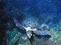
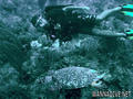
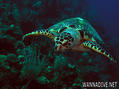
Útila (Isla de Útila) is the third largest of Honduras' Bay Islands, after Roatán and Guanaja, in a region that marks the south end of the Mesoamerican Barrier Reef System, the second-largest in the world. The eastern end of the island is capped by a thin veneer of basaltic volcanic rocks, erupted from several pyroclastic cones including 74 m (243 ft) Pumpkin Hill which forms the highest point on the island. It has been documented in history since Columbus' fourth voyage, and currently enjoys growing tourism with emphasis on recreational diving.
English (Translate this text in English): Útila (Isla de Útila) is the third largest of Honduras' Bay Islands, after Roatán and Guanaja, in a region that marks the south end of the Mesoamerican Barrier Reef System, the second-largest in the world. The eastern end of the island is capped by a thin veneer of basaltic volcanic rocks, erupted from several pyroclastic cones including 74 m (243 ft) Pumpkin Hill which forms the highest point on the island. It has been documented in history since Columbus' fourth voyage, and currently enjoys growing tourism with emphasis on recreational diving.
English (Translate this text in English): Útila (Isla de Útila) is the third largest of Honduras' Bay Islands, after Roatán and Guanaja, in a region that marks the south end of the Mesoamerican Barrier Reef System, the second-largest in the world. The eastern end of the island is capped by a thin veneer of basaltic volcanic rocks, erupted from several pyroclastic cones including 74 m (243 ft) Pumpkin Hill which forms the highest point on the island. It has been documented in history since Columbus' fourth voyage, and currently enjoys growing tourism with emphasis on recreational diving.
English (Translate this text in English): Útila (Isla de Útila) is the third largest of Honduras' Bay Islands, after Roatán and Guanaja, in a region that marks the south end of the Mesoamerican Barrier Reef System, the second-largest in the world. The eastern end of the island is capped by a thin veneer of basaltic volcanic rocks, erupted from several pyroclastic cones including 74 m (243 ft) Pumpkin Hill which forms the highest point on the island. It has been documented in history since Columbus' fourth voyage, and currently enjoys growing tourism with emphasis on recreational diving.
English (Translate this text in English): Útila (Isla de Útila) is the third largest of Honduras' Bay Islands, after Roatán and Guanaja, in a region that marks the south end of the Mesoamerican Barrier Reef System, the second-largest in the world. The eastern end of the island is capped by a thin veneer of basaltic volcanic rocks, erupted from several pyroclastic cones including 74 m (243 ft) Pumpkin Hill which forms the highest point on the island. It has been documented in history since Columbus' fourth voyage, and currently enjoys growing tourism with emphasis on recreational diving.
English (Translate this text in English): Útila (Isla de Útila) is the third largest of Honduras' Bay Islands, after Roatán and Guanaja, in a region that marks the south end of the Mesoamerican Barrier Reef System, the second-largest in the world. The eastern end of the island is capped by a thin veneer of basaltic volcanic rocks, erupted from several pyroclastic cones including 74 m (243 ft) Pumpkin Hill which forms the highest point on the island. It has been documented in history since Columbus' fourth voyage, and currently enjoys growing tourism with emphasis on recreational diving.
English (Translate this text in English): Útila (Isla de Útila) is the third largest of Honduras' Bay Islands, after Roatán and Guanaja, in a region that marks the south end of the Mesoamerican Barrier Reef System, the second-largest in the world. The eastern end of the island is capped by a thin veneer of basaltic volcanic rocks, erupted from several pyroclastic cones including 74 m (243 ft) Pumpkin Hill which forms the highest point on the island. It has been documented in history since Columbus' fourth voyage, and currently enjoys growing tourism with emphasis on recreational diving.
 Útila Island


 Comments