This is an interactive map! Use controls to pan and zoom this map.
Access
|
English (Translate this text in English): Saranda bay
English (Translate this text in English): Saranda bay
Saranda bay
English (Translate this text in English): Saranda bay
English (Translate this text in English): Saranda bay
English (Translate this text in English): Saranda bay
English (Translate this text in English): Saranda bay
English (Translate this text in English): Saranda bay
English (Translate this text in English): Saranda bay
How?
Distance
Easy to find?
|
|
Dive site Characteristics
Average depth 15 m / 49.2 ft
Max depth 30 m / 98.4 ft
Current
Visibility
Quality
Dive site quality
Experience
Bio interest
More details
Week crowd
Week-end crowd
Dive type
Dive site activities
Dangers
Additional Information
English (Translate this text in English): Inside the Bay of Saranda there lies an Italian cargoship. It was sunk during the II World War by German Bombers on their way back from an attack on the Balkans. Traces of the bombs can still be seen on the ships sides! The vessel lies on its port side on the sandy bed at a maximum depth of 18m just 300m away from the shore. At the shallowest point the ship is just 3m form the surface and is marked with a bouy. The ship is roughly 115m long. It is marked above water by a Cardinal bouy signalling danger. Visibility underwater is good about 20m.
English (Translate this text in English): Inside the Bay of Saranda there lies an Italian cargoship. It was sunk during the II World War by German Bombers on their way back from an attack on the Balkans. Traces of the bombs can still be seen on the ships sides! The vessel lies on its port side on the sandy bed at a maximum depth of 18m just 300m away from the shore. At the shallowest point the ship is just 3m form the surface and is marked with a bouy. The ship is roughly 115m long. It is marked above water by a Cardinal bouy signalling danger. Visibility underwater is good about 20m.
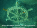
Inside the Bay of Saranda there lies an Italian cargoship. It was sunk during the II World War by German Bombers on their way back from an attack on the Balkans. Traces of the bombs can still be seen on the ships sides! The vessel lies on its port side on the sandy bed at a maximum depth of 18m just 300m away from the shore. At the shallowest point the ship is just 3m form the surface and is marked with a bouy. The ship is roughly 115m long. It is marked above water by a Cardinal bouy signalling danger. Visibility underwater is good about 20m.
English (Translate this text in English): Inside the Bay of Saranda there lies an Italian cargoship. It was sunk during the II World War by German Bombers on their way back from an attack on the Balkans. Traces of the bombs can still be seen on the ships sides! The vessel lies on its port side on the sandy bed at a maximum depth of 18m just 300m away from the shore. At the shallowest point the ship is just 3m form the surface and is marked with a bouy. The ship is roughly 115m long. It is marked above water by a Cardinal bouy signalling danger. Visibility underwater is good about 20m.
English (Translate this text in English): Inside the Bay of Saranda there lies an Italian cargoship. It was sunk during the II World War by German Bombers on their way back from an attack on the Balkans. Traces of the bombs can still be seen on the ships sides! The vessel lies on its port side on the sandy bed at a maximum depth of 18m just 300m away from the shore. At the shallowest point the ship is just 3m form the surface and is marked with a bouy. The ship is roughly 115m long. It is marked above water by a Cardinal bouy signalling danger. Visibility underwater is good about 20m.
English (Translate this text in English): Inside the Bay of Saranda there lies an Italian cargoship. It was sunk during the II World War by German Bombers on their way back from an attack on the Balkans. Traces of the bombs can still be seen on the ships sides! The vessel lies on its port side on the sandy bed at a maximum depth of 18m just 300m away from the shore. At the shallowest point the ship is just 3m form the surface and is marked with a bouy. The ship is roughly 115m long. It is marked above water by a Cardinal bouy signalling danger. Visibility underwater is good about 20m.
English (Translate this text in English): Inside the Bay of Saranda there lies an Italian cargoship. It was sunk during the II World War by German Bombers on their way back from an attack on the Balkans. Traces of the bombs can still be seen on the ships sides! The vessel lies on its port side on the sandy bed at a maximum depth of 18m just 300m away from the shore. At the shallowest point the ship is just 3m form the surface and is marked with a bouy. The ship is roughly 115m long. It is marked above water by a Cardinal bouy signalling danger. Visibility underwater is good about 20m.
English (Translate this text in English): Inside the Bay of Saranda there lies an Italian cargoship. It was sunk during the II World War by German Bombers on their way back from an attack on the Balkans. Traces of the bombs can still be seen on the ships sides! The vessel lies on its port side on the sandy bed at a maximum depth of 18m just 300m away from the shore. At the shallowest point the ship is just 3m form the surface and is marked with a bouy. The ship is roughly 115m long. It is marked above water by a Cardinal bouy signalling danger. Visibility underwater is good about 20m.
English (Translate this text in English): Inside the Bay of Saranda there lies an Italian cargoship. It was sunk during the II World War by German Bombers on their way back from an attack on the Balkans. Traces of the bombs can still be seen on the ships sides! The vessel lies on its port side on the sandy bed at a maximum depth of 18m just 300m away from the shore. At the shallowest point the ship is just 3m form the surface and is marked with a bouy. The ship is roughly 115m long. It is marked above water by a Cardinal bouy signalling danger. Visibility underwater is good about 20m.
 Comments
Please login to use this tool.
No account yet? Register first; it's free!
Show all (0)...
Be the first to comment this country
Errors, Feedback
You can edit this page to correct errors or add new information. If you have any problems regarding this page, Send us feedback.
Wannadive.net 24/24
Wannadive.net on your mobile

Newsletter All news by email
 Italian Freighter Probitas