This is an interactive map! Use controls to pan and zoom this map.
Access
|
English (Translate this text in English): The wreck is 600m S SW from the Grand Ribaud lighthouse.
English (Translate this text in English): The wreck is 600m S SW from the Grand Ribaud lighthouse.
The wreck is 600m S SW from the Grand Ribaud lighthouse.
English (Translate this text in English): The wreck is 600m S SW from the Grand Ribaud lighthouse.
Des mises à l'eau sur Carqueiranne, Le Pradet, Hyères (Port d'Hyères,La Tour Fondue,le port du Niel et La Madrague) Attention La tour Fondue est souvent interdite à la mise à l'eau pour raison de sécurité le plan incliné serait glissant!!!!mais je n'ai pas d'information car je parts du Port de La Capte
Certains bateaux partent de La Londe les Maures (port de Miramar) il y a une super mise à l'eau souvent payante mais aussi un très beau parking à remorques et à voitures, beaucoup de monde le soir pour sortir les bateaux il faut s'organiser et être à plusieurs pour faire la queue des voitures et des bateaux( parfois 6 à 7 bateaux)!!!
Si vous avez des informations faites nous le savoir!!!
English (Translate this text in English): The wreck is 600m S SW from the Grand Ribaud lighthouse.
English (Translate this text in English): The wreck is 600m S SW from the Grand Ribaud lighthouse.
English (Translate this text in English): The wreck is 600m S SW from the Grand Ribaud lighthouse.
English (Translate this text in English): The wreck is 600m S SW from the Grand Ribaud lighthouse.
How? By boat
Distance Short boat time (< 10min)
Easy to find? Hard to find
|
|
Dive site Characteristics
Average depth 43.0 m / 141.1 ft
Max depth 49.0 m / 160.8 ft
Current Medium ( 1-2 knots)
Visibility Medium ( 5 - 10 m)
Quality
Dive site quality Good
Experience CMAS *** / DiveMaster
Bio interest Poor
More details
Week crowd
Week-end crowd
Dive type
- Wreck
- Deep
- Ambiance
Dive site activities
- Marine biology
- Photography
Dangers
- Depth
Additional Information
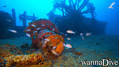
English (Translate this text in English): Vapor boat with interesting paddle wheels, the only interesting part of the wreck...
English (Translate this text in English): Vapor boat with interesting paddle wheels, the only interesting part of the wreck...
Vapor boat with interesting paddle wheels, the only interesting part of the wreck...
English (Translate this text in English): Vapor boat with interesting paddle wheels, the only interesting part of the wreck...
Vapeur en fer à roues à aube, naufrage le 15 décembre 1851
Le Ville de grasse est coupé en deux parties la plus profonde est la proue à 50m de profondeur, la partie la plus visitée est la poupe, à 49m sur un fond de sable.
La proue très peu intéressante et est visible au point:
GPS:43°00.622'N 006°08.464'E Impossible d'aller de l'avant qui est à 51 m à l'arrière qui est à 49m Distance entre les deux parties 60m!!!
Deux roues à aube sont très visitées et photographiées!!
Il est possible et facile après la visite de l'épave de partir vers le Michel C qui est à 60m et moins profond. Attention à la consommation d'air!!!
Suivez l'axe du Ville de Grasse cap 340 dès que vous avez perdu de vue le Ville de Grasse vous voyez apparaitre les premiers rochers du Michel C continuez à remonter vers 30m et vous trouverez cette épave.
Petite visite et paliers s'en suivent
English (Translate this text in English): Vapor boat with interesting paddle wheels, the only interesting part of the wreck...
English (Translate this text in English): Vapor boat with interesting paddle wheels, the only interesting part of the wreck...
English (Translate this text in English): Vapor boat with interesting paddle wheels, the only interesting part of the wreck...
English (Translate this text in English): Vapor boat with interesting paddle wheels, the only interesting part of the wreck...
 Comments
Please login to use this tool.
No account yet? Register first; it's free!
Show all (0)...
Be the first to comment this country
Errors, Feedback
You can edit this page to correct errors or add new information. If you have any problems regarding this page, Send us feedback.
Wannadive.net 24/24
Wannadive.net on your mobile

Newsletter All news by email
 Le Ville de Grasse