This is an interactive map! Use controls to pan and zoom this map.
Access
|
English (Translate this text in English): Head for Othmans Reef, then at the final dune, turn right along the beach. Cross the sabkha till you get to the first dune at the sea edge. Not accessible at some states of the tide.
English (Translate this text in English): Head for Othmans Reef, then at the final dune, turn right along the beach. Cross the sabkha till you get to the first dune at the sea edge. Not accessible at some states of the tide.
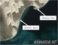
Head for Othmans Reef, then at the final dune, turn right along the beach. Cross the sabkha till you get to the first dune at the sea edge. Not accessible at some states of the tide.
English (Translate this text in English): Head for Othmans Reef, then at the final dune, turn right along the beach. Cross the sabkha till you get to the first dune at the sea edge. Not accessible at some states of the tide.
English (Translate this text in English): Head for Othmans Reef, then at the final dune, turn right along the beach. Cross the sabkha till you get to the first dune at the sea edge. Not accessible at some states of the tide.
English (Translate this text in English): Head for Othmans Reef, then at the final dune, turn right along the beach. Cross the sabkha till you get to the first dune at the sea edge. Not accessible at some states of the tide.
English (Translate this text in English): Head for Othmans Reef, then at the final dune, turn right along the beach. Cross the sabkha till you get to the first dune at the sea edge. Not accessible at some states of the tide.
English (Translate this text in English): Head for Othmans Reef, then at the final dune, turn right along the beach. Cross the sabkha till you get to the first dune at the sea edge. Not accessible at some states of the tide.
English (Translate this text in English): Head for Othmans Reef, then at the final dune, turn right along the beach. Cross the sabkha till you get to the first dune at the sea edge. Not accessible at some states of the tide.
How? From shore
Distance Short walk from shore (< 5min)
Easy to find? Hard to find
|
|
Dive site Characteristics
Alternative name Olivier Bank reef
Average depth 7 m / 23 ft
Max depth 9 m / 29.5 ft
Current Low ( < 1 knot)
Visibility Medium ( 5 - 10 m)
Quality
Dive site quality Standard
Experience All divers
Bio interest Interesting
More details
Week crowd
Week-end crowd
Dive type
- Reef
Dive site activities
- Marine biology
Dangers
Additional Information
English (Translate this text in English): 3 natural coral reefs. Named for Olivier, the club member who found the reef. Zeitoune is Arabic for olive.
Often rays on sandy crossing. The southernmost reef often has large hamour Fish at the bottom of the reef wall.
As you swim the gap, the depth will decrease as you approach the reef. If it starts getting quite deep, it means you have passed it. Turn back to shallow area, then turn either North or South
3 natural coral reefs. Named for Olivier, the club member who found the reef. Zeitoune is Arabic for olive.
Often rays on sandy crossing. The southernmost reef often has large hamour Fish at the bottom of the reef wall.
As you swim the gap, the depth will decrease as you approach the reef. If it starts getting quite deep, it means you have passed it. Turn back to shallow area, then turn either North or South
English (Translate this text in English): 3 natural coral reefs. Named for Olivier, the club member who found the reef. Zeitoune is Arabic for olive.
Often rays on sandy crossing. The southernmost reef often has large hamour Fish at the bottom of the reef wall.
As you swim the gap, the depth will decrease as you approach the reef. If it starts getting quite deep, it means you have passed it. Turn back to shallow area, then turn either North or South
 Comments
Please login to use this tool.
No account yet? Register first; it's free!
Show all (0)...
Be the first to comment this country
Errors, Feedback
You can edit this page to correct errors or add new information. If you have any problems regarding this page, Send us feedback.
Wannadive.net 24/24
Wannadive.net on your mobile

Newsletter All news by email
 Zeitoune Bank